
Make a donation
Gear up for your next adventure:
As an Amazon Associate, this site earns from qualifying purchases at no extra cost to you.
Frohnhausen topographic map
Click on the map to display elevation.
Make a donation
Gear up for your next adventure:
As an Amazon Associate, this site earns from qualifying purchases at no extra cost to you.
Frohnhausen
1407 wurde der Ort das erste Mal in einer Urkunde über den Verzicht des Stael v. Holstein auf das bergische Erbdrosten- und Erbhofmeisteramt erwähnt. Schreibweise der Erstnennung: Vronen Huis. Die Karte Topographia Ducatus Montani aus dem Jahre 1715 zeigt den Hof als Frohnhusen. Im 18. Jahrhundert gehörte der Ort zum bergischen Amt Bornefeld-Hückeswagen.
Make a donation
Gear up for your next adventure:
As an Amazon Associate, this site earns from qualifying purchases at no extra cost to you.
About this map
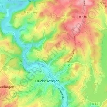
Name: Frohnhausen topographic map, elevation, terrain.
Average elevation: 1,007 ft
Minimum elevation: 814 ft
Maximum elevation: 1,227 ft
Make a donation
Gear up for your next adventure:
As an Amazon Associate, this site earns from qualifying purchases at no extra cost to you.
Other topographic maps
Click on a map to view its topography, its elevation and its terrain.
42499
Deutschland > Nordrhein-Westfalen > Oberbergischer Kreis > Hückeswagen > Aue
Average elevation: 958 ft