
Make a donation
Gear up for your next adventure:
As an Amazon Associate, this site earns from qualifying purchases at no extra cost to you.
Kasen topographic map
Click on the map to display elevation.
Make a donation
Gear up for your next adventure:
As an Amazon Associate, this site earns from qualifying purchases at no extra cost to you.
Kasen
Kasen (Limburgs: Kaze) is een landelijke buurtschap in de gemeente Meerssen in Nederlands Limburg. Kasen ligt zes kilometer ten noordoosten van Maastricht en twee kilometer ten noordoosten van Bunde op het plateau van de Kruisberg (plaatselijk ook bekend als Dennenberg), op 112 meter hoogte tussen het Bunderbos en Maastricht Aachen Airport. Ten zuidwesten van Kasen ontspringt de Overbundebeek.
Make a donation
Gear up for your next adventure:
As an Amazon Associate, this site earns from qualifying purchases at no extra cost to you.
About this map
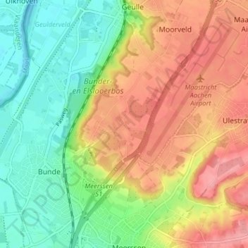
Name: Kasen topographic map, elevation, terrain.
Location: Kasen, Bunde, Meerssen, Limburg, Nederland, 6241 NV, Nederland (50.88510 5.73174 50.92510 5.77174)
Average elevation: 266 ft
Minimum elevation: 118 ft
Maximum elevation: 423 ft
Make a donation
Gear up for your next adventure:
As an Amazon Associate, this site earns from qualifying purchases at no extra cost to you.