
Make a donation
Gear up for your next adventure:
As an Amazon Associate, this site earns from qualifying purchases at no extra cost to you.
Gadertal - Val Badia topographic map
Click on the map to display elevation.
Make a donation
Gear up for your next adventure:
As an Amazon Associate, this site earns from qualifying purchases at no extra cost to you.
About this map
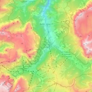
Name: Gadertal - Val Badia topographic map, elevation, terrain.
Average elevation: 6,079 ft
Minimum elevation: 2,631 ft
Maximum elevation: 10,518 ft
Make a donation
Gear up for your next adventure:
As an Amazon Associate, this site earns from qualifying purchases at no extra cost to you.
Other topographic maps
Click on a map to view its topography, its elevation and its terrain.
Bolzano - Bozen
Italy > Trentino – Alto Adige/Südtirol > South Tyrol
The area of the city of Bolzano is 52.3 km2 (20 sq. mi.), of which 28 km2 (10 sq. mi.) is used as a settlement area. The city is located in the basin where the Sarntal, Eisacktal, and the Adige Valley with their rivers, Talfer, Eisack, and Adige, meet. In the Middle Ages, the two main Alpine crossings, the Via…
Average elevation: 2,349 ft
Urtijëi - St. Ulrich in Gröden - Ortisei
Italy > Trentino – Alto Adige/Südtirol > South Tyrol
To the north and northeast, above the valley floor of Urtijëi, lie the western foothills of the Geisler Group, part of the Dolomites. In the northeast, the municipality reaches its highest point at Seceda (2519 m, Secëda). South of Seceda, the Pitschberg (2363 m, Pic) projects into the valley. To the west of…
Average elevation: 5,541 ft
Froi - Froia
Italy > Trentino – Alto Adige/Südtirol > South Tyrol > Graun - Curon Venosta
Average elevation: 5,856 ft
Make a donation
Gear up for your next adventure:
As an Amazon Associate, this site earns from qualifying purchases at no extra cost to you.
Urtijëi - St. Ulrich in Gröden - Ortisei
Italy > Trentino – Alto Adige/Südtirol > South Tyrol
To the north and northeast, above the valley floor of Urtijëi, lie the western foothills of the Geisler Group, part of the Dolomites. In the northeast, the municipality reaches its highest point at Seceda (2519 m, Secëda). South of Seceda, the Pitschberg (2363 m, Pic) projects into the valley. To the west of…
Average elevation: 5,541 ft
Welsberg - Monguelfo
Italy > Trentino – Alto Adige/Südtirol > South Tyrol > Welsberg-Taisten - Monguelfo-Tesido
Average elevation: 4,229 ft
Secëda - Monte Seceda
Italy > Trentino – Alto Adige/Südtirol > South Tyrol > Santa Cristina Gherdëina - St. Christina in Gröden - Santa Cristina Valgardena
Monte Seceda is a 2,519-meter-elevation (8,264-foot) summit in the Odles Group of the Dolomites, a UNESCO World Heritage Site. Set in the Trentino-Alto Adige/Südtirol region, the peak is located four kilometers (2.5 miles) north of the village of Santa Cristina Gherdëina, and the peak is in Puez-Geisler…
Average elevation: 6,909 ft
Meran - Merano
Italy > Trentino – Alto Adige/Südtirol > South Tyrol
The average daily temperatures in summer in Merano lie between 27 and 30 °C, while at night temperatures usually drop to between 12 and 15 °C. The average daily temperatures in winter lie between 6 and 10 °C, while at night temperatures usually drop to between -4 and -2 °C. The wettest month is August with…
Average elevation: 2,083 ft
Make a donation
Gear up for your next adventure:
As an Amazon Associate, this site earns from qualifying purchases at no extra cost to you.
Schmieden - Ferrara
Italy > Trentino – Alto Adige/Südtirol > South Tyrol > Prags - Braies
Average elevation: 4,678 ft
Meran - Merano
Italy > Trentino – Alto Adige/Südtirol > South Tyrol
The average daily temperatures in summer in Merano lie between 27 and 30 °C, while at night temperatures usually drop to between 12 and 15 °C. The average daily temperatures in winter lie between 6 and 10 °C, while at night temperatures usually drop to between -4 and -2 °C. The wettest month is August with…
Average elevation: 2,083 ft
Ritten - Renon
Italy > Trentino – Alto Adige/Südtirol > South Tyrol
The 111-square-kilometre (43 sq mi) community is named after the high plateau, elevation 1,100 to 1,400 metres (3,600 to 4,600 ft), the Ritten or the Renon, on which most of the villages are located. The plateau forms the southeast tip of the Sarntal Alps mountain range and is located between, and on average…
Average elevation: 3,684 ft
Rasen-Antholz - Rasun-Anterselva
Italy > Trentino – Alto Adige/Südtirol > South Tyrol
Rasen-Antholz is known for the South Tyrol Arena biathlon track, which opened in 1971. It hosted the Biathlon World Championships in 1975, 1976, 1983, 1995, 2007 and 2020. It is also a regular venue of the Biathlon World Cup season, with the highest altitude of all World Cup meetings at a height of about 1,600…
Average elevation: 6,345 ft
Make a donation
Gear up for your next adventure:
As an Amazon Associate, this site earns from qualifying purchases at no extra cost to you.
Pinzon - Pinzano
Italy > Trentino – Alto Adige/Südtirol > South Tyrol > Montan an der Weinstraße - Montagna sulla Strada del Vino
Average elevation: 1,719 ft
Schlern - Sciliar
Italy > Trentino – Alto Adige/Südtirol > South Tyrol > Völs am Schlern - Fiè allo Sciliar
Average elevation: 6,670 ft
Make a donation
Gear up for your next adventure:
As an Amazon Associate, this site earns from qualifying purchases at no extra cost to you.
Kaltern an der Weinstraße - Caldaro sulla Strada del Vino
Italy > Trentino – Alto Adige/Südtirol > South Tyrol
Average elevation: 2,618 ft
Bolzano - Bozen
Italy > Trentino – Alto Adige/Südtirol > South Tyrol
The area of the city of Bolzano is 52.3 km2 (20.2 sq mi), of which 28 km2 (11 sq mi) is used as a settlement area. The city is located in the basin where the Sarntal, Eisacktal, and the Adige Valley with their rivers, Talfer, Eisack, and Adige, meet. In the Middle Ages, the two main Alpine crossings, the Via…
Average elevation: 2,349 ft
Maring
Italy > Trentino – Alto Adige/Südtirol > South Tyrol > La Ila - Stern - La Villa
Average elevation: 5,666 ft
Make a donation
Gear up for your next adventure:
As an Amazon Associate, this site earns from qualifying purchases at no extra cost to you.
Bruneck - Brunico
Italy > Trentino – Alto Adige/Südtirol > South Tyrol
Bruneck rises up in the middle of a wide valley (perhaps an ancient lake basin) and lies at the confluence of the Ahr with the Rienz, which itself flows into the Eisack river. Here the northern Tauferer Ahrntal side valley and the southern Val Badia of the Gran Ega creek join the broad Pustertal. Bruneck wide…
Average elevation: 4,104 ft
Corvara in Badia - Corvara
Italy > Trentino – Alto Adige/Südtirol > South Tyrol
Average elevation: 6,683 ft
Ritten - Renon
Italy > Trentino – Alto Adige/Südtirol > South Tyrol
The 111-square-kilometre (43 sq mi) community is named after the high plateau, elevation 1,100 to 1,400 metres (3,600 to 4,600 ft), the Ritten or the Renon, on which most of the villages are located. The plateau forms the southeast tip of the Sarntal Alps mountain range and is located between, and on average…
Average elevation: 3,684 ft
Make a donation
Gear up for your next adventure:
As an Amazon Associate, this site earns from qualifying purchases at no extra cost to you.
San Martin de Tor - San Martino in Badia - St. Martin in Thurn
Italy > Trentino – Alto Adige/Südtirol > South Tyrol
Average elevation: 6,027 ft
Gufidaun - Gudon
Italy > Trentino – Alto Adige/Südtirol > South Tyrol > Klausen - Chiusa
Average elevation: 2,822 ft
Secëda - Monte Seceda
Italy > Trentino – Alto Adige/Südtirol > South Tyrol > Santa Cristina Gherdëina - St. Christina in Gröden - Santa Cristina Valgardena
Monte Seceda is a 2,519-meter-elevation (8,264-foot) summit in the Odles Group of the Dolomites, a UNESCO World Heritage Site. Set in the Trentino-Alto Adige/Südtirol region, the peak is located four kilometers (2.5 miles) north of the village of Santa Cristina Gherdëina, and the peak is in Puez-Geisler…
Average elevation: 6,909 ft
Quellenhof - Sorgente
Italy > Trentino – Alto Adige/Südtirol > South Tyrol
Average elevation: 3,291 ft
Make a donation
Gear up for your next adventure:
As an Amazon Associate, this site earns from qualifying purchases at no extra cost to you.
Sulden - Solda
Italy > Trentino – Alto Adige/Südtirol > South Tyrol > Stilfs - Stelvio
Average elevation: 7,323 ft
Salorno sulla Strada del Vino - Salurn an der Weinstraße
Italy > Trentino – Alto Adige/Südtirol > South Tyrol
Average elevation: 2,539 ft
Kampenn - Campegno
Italy > Trentino – Alto Adige/Südtirol > South Tyrol > Bolzano > Rentsch - Rencio
Average elevation: 2,198 ft
Make a donation
Gear up for your next adventure:
As an Amazon Associate, this site earns from qualifying purchases at no extra cost to you.
Ahrntal - Valle Aurina
Italy > Trentino – Alto Adige/Südtirol > South Tyrol
Weißenbach is composed of picturesque Alpine farmhouses, grouped around the foaming white glacial stream from which its name is derived. With a population of around 550, it has an elevation of 1,350 metres (4,430 ft) above sea level.
Average elevation: 6,821 ft
Siebeneich - Settequerce
Italy > Trentino – Alto Adige/Südtirol > South Tyrol
Average elevation: 1,401 ft
Make a donation
Gear up for your next adventure:
As an Amazon Associate, this site earns from qualifying purchases at no extra cost to you.
St. Georg - San Giorgio di Eores
Italy > Trentino – Alto Adige/Südtirol > South Tyrol > Brixen - Bressanone
Average elevation: 4,843 ft
Schneespitz - Cima della Neve
Italy > Trentino – Alto Adige/Südtirol > South Tyrol > Predoi
Average elevation: 8,192 ft
Obereggen - San Floriano d'Ega
Italy > Trentino – Alto Adige/Südtirol > South Tyrol > Deutschnofen - Nova Ponente
Average elevation: 5,413 ft
Make a donation
Gear up for your next adventure:
As an Amazon Associate, this site earns from qualifying purchases at no extra cost to you.
Croda del Becco - Sas dla Porta - Seekofel
Italy > Trentino – Alto Adige/Südtirol > South Tyrol > Prags - Braies
Average elevation: 7,172 ft
La Val - Wengen - La Valle
Italy > Trentino – Alto Adige/Südtirol > South Tyrol
Average elevation: 5,476 ft
Flading - Vallettina
Italy > Trentino – Alto Adige/Südtirol > South Tyrol > Ratschings - Racines
Average elevation: 6,601 ft
Make a donation
Gear up for your next adventure:
As an Amazon Associate, this site earns from qualifying purchases at no extra cost to you.
Urtijëi - St. Ulrich in Gröden - Ortisei
Italy > Trentino – Alto Adige/Südtirol > South Tyrol
To the north and northeast, above the valley floor of Urtijëi, lie the western foothills of the Geisler Group, part of the Dolomites. In the northeast, the municipality reaches its highest point at Seceda (2519 m, Secëda). South of Seceda, the Pitschberg (2363 m, Pic) projects into the valley. To the west of…
Average elevation: 5,541 ft
Kastelruth - Castelrotto
Italy > Trentino – Alto Adige/Südtirol > South Tyrol
Average elevation: 5,121 ft
Pragser Wildsee - Lago di Braies
Italy > Trentino – Alto Adige/Südtirol > South Tyrol > Prags - Braies
Average elevation: 5,722 ft
Make a donation
Gear up for your next adventure:
As an Amazon Associate, this site earns from qualifying purchases at no extra cost to you.
Obermais - Maia Alta
Italy > Trentino – Alto Adige/Südtirol > South Tyrol > Meran - Merano
Average elevation: 1,585 ft
Bolzano - Bozen
Italy > Trentino – Alto Adige/Südtirol > South Tyrol
The area of the city of Bolzano is 52.3 km2 (20.2 sq mi), of which 28 km2 (11 sq mi) is used as a settlement area. The city is located in the basin where the Sarntal, Eisacktal, and the Adige Valley with their rivers, Talfer, Eisack, and Adige, meet. In the Middle Ages, the two main Alpine crossings, the Via…
Average elevation: 2,349 ft
Neumarkt - Egna
Italy > Trentino – Alto Adige/Südtirol > South Tyrol
The town is situated on the plain, elevation 214 metres (702 ft), on the left side of the Adige river.
Average elevation: 2,493 ft
Funtanacia
Italy > Trentino – Alto Adige/Südtirol > South Tyrol > La Ila - Stern - La Villa
Average elevation: 5,863 ft
Make a donation
Gear up for your next adventure:
As an Amazon Associate, this site earns from qualifying purchases at no extra cost to you.
Mitterdorf - Caldaro di Mezzo
Italy > Trentino – Alto Adige/Südtirol > South Tyrol > St. Nikolaus - San Nicolò
Average elevation: 2,178 ft
Martell - Martello
Italy > Trentino – Alto Adige/Südtirol > South Tyrol
Martell (German pronunciation: [marˈtɛl]; Italian: Martello [marˈtɛllo]) is a valley and comune (municipality) in South Tyrol in northern Italy. It is located in the Martell Valley of the 28.5-kilometre (17.7 mi) long river Plima, about 45 kilometres (28 mi) west of Bolzano. The commune reaches from an…
Average elevation: 8,241 ft
Ortler - Ortles
Italy > Trentino – Alto Adige/Südtirol > South Tyrol > Stilfs - Stelvio
The Ortler was first climbed by Josef Pichler [de] ("Pseirer-Josele"), a chamois hunter from St. Leonhard in Passeier, and his companions Johann Leitner and Johann Klausner from Zell am Ziller on 27 September 1804. The ascent had been a request of Archduke Johann of Austria, who felt strongly that after the…
Average elevation: 10,417 ft
Make a donation
Gear up for your next adventure:
As an Amazon Associate, this site earns from qualifying purchases at no extra cost to you.
Siebeneich - Settequerce
Italy > Trentino – Alto Adige/Südtirol > South Tyrol
Average elevation: 1,401 ft
La Val - Wengen - La Valle
Italy > Trentino – Alto Adige/Südtirol > South Tyrol
Average elevation: 5,476 ft
Make a donation
Gear up for your next adventure:
As an Amazon Associate, this site earns from qualifying purchases at no extra cost to you.
Antlas
Italy > Trentino – Alto Adige/Südtirol > South Tyrol > Ritten - Renon > Atzwang - Campodazzo
Average elevation: 2,684 ft
La Val - Wengen - La Valle
Italy > Trentino – Alto Adige/Südtirol > South Tyrol
Average elevation: 5,476 ft
Make a donation
Gear up for your next adventure:
As an Amazon Associate, this site earns from qualifying purchases at no extra cost to you.
Nock
Italy > Trentino – Alto Adige/Südtirol > South Tyrol > Ratschings - Racines
Average elevation: 5,889 ft
Ritten - Renon
Italy > Trentino – Alto Adige/Südtirol > South Tyrol
The 111-square-kilometre (43 mi2) community is named after the high plateau, elevation 1,100 to 1,400 metres (3,600 to 4,600 ft), the Ritten or the Renon, on which most of the villages are located. The plateau forms the southeast tip of the Sarntal Alps mountain range and is located between, and on average 800…
Average elevation: 3,684 ft
Make a donation
Gear up for your next adventure:
As an Amazon Associate, this site earns from qualifying purchases at no extra cost to you.
Ahrntal - Valle Aurina
Italy > Trentino – Alto Adige/Südtirol > South Tyrol
Weißenbach is composed of picturesque Alpine farmhouses, grouped around the foaming white glacial stream from which its name is derived. With a population of around 550, it has an elevation of 1,350 metres (4,430 ft) above sea level.
Average elevation: 6,821 ft
Make a donation
Gear up for your next adventure:
As an Amazon Associate, this site earns from qualifying purchases at no extra cost to you.
Salorno sulla Strada del Vino - Salurn an der Weinstraße
Italy > Trentino – Alto Adige/Südtirol > South Tyrol
Average elevation: 2,539 ft
Make a donation
Gear up for your next adventure:
As an Amazon Associate, this site earns from qualifying purchases at no extra cost to you.
Schluderbach - Carbonin
Italy > Trentino – Alto Adige/Südtirol > South Tyrol > Toblach - Dobbiaco
Average elevation: 5,827 ft
Corvara in Badia - Corvara
Italy > Trentino – Alto Adige/Südtirol > South Tyrol
Average elevation: 6,683 ft
Antermëia - Untermoi - Antermoia
Italy > Trentino – Alto Adige/Südtirol > South Tyrol > San Martin de Tor - San Martino in Badia - St. Martin in Thurn
Average elevation: 5,502 ft
Sarns - Sarnes
Italy > Trentino – Alto Adige/Südtirol > South Tyrol > Brixen - Bressanone
Average elevation: 2,382 ft
Make a donation
Gear up for your next adventure:
As an Amazon Associate, this site earns from qualifying purchases at no extra cost to you.
St. Anton - Sant'Antonio
Italy > Trentino – Alto Adige/Südtirol > South Tyrol > St. Nikolaus - San Nicolò
Average elevation: 2,444 ft
Urtijëi - St. Ulrich in Gröden - Ortisei
Italy > Trentino – Alto Adige/Südtirol > South Tyrol
Average elevation: 5,541 ft
Make a donation
Gear up for your next adventure:
As an Amazon Associate, this site earns from qualifying purchases at no extra cost to you.
Costadedoi
Italy > Trentino – Alto Adige/Südtirol > South Tyrol > San Ćiascian - St. Kassian - San Cassiano
Average elevation: 5,617 ft
Obereggen - San Floriano d'Ega
Italy > Trentino – Alto Adige/Südtirol > South Tyrol > Deutschnofen - Nova Ponente
Average elevation: 5,413 ft
St. Magdalena - Santa Maddalena in Casies
Italy > Trentino – Alto Adige/Südtirol > South Tyrol > Gsies - Valle di Casies
Average elevation: 5,814 ft
Make a donation
Gear up for your next adventure:
As an Amazon Associate, this site earns from qualifying purchases at no extra cost to you.
Meran - Merano
Italy > Trentino – Alto Adige/Südtirol > South Tyrol
The average daily temperatures in summer in Merano lie between 27 and 30 °C, while at night temperatures usually drop to between 12 and 15 °C. The average daily temperatures in winter lie between 6 and 10 °C, while at night temperatures usually drop to between -4 and -2 °C. The wettest month is August with…
Average elevation: 2,083 ft
Seis am Schlern - Siusi allo Sciliar
Italy > Trentino – Alto Adige/Südtirol > South Tyrol > Kastelruth - Castelrotto
Average elevation: 3,973 ft
Al Plan de Mareo - St. Vigil in Enneberg - San Vigilio di Marebbe
Italy > Trentino – Alto Adige/Südtirol > South Tyrol > Marèo - Enneberg - Marebbe
Average elevation: 4,616 ft
Make a donation
Gear up for your next adventure:
As an Amazon Associate, this site earns from qualifying purchases at no extra cost to you.
Schluderns - Sluderno
Italy > Trentino – Alto Adige/Südtirol > South Tyrol
Average elevation: 3,802 ft
Mühlbach - Rio di Pusteria
Italy > Trentino – Alto Adige/Südtirol > South Tyrol
Average elevation: 5,699 ft
Make a donation
Gear up for your next adventure:
As an Amazon Associate, this site earns from qualifying purchases at no extra cost to you.
Lengmoos - Longomoso
Italy > Trentino – Alto Adige/Südtirol > South Tyrol > Ritten - Renon > Klobenstein - Collalbo
Average elevation: 3,442 ft
Hoher Weißzint - Punta Bianca
Italy > Trentino – Alto Adige/Südtirol > South Tyrol > Mühlwald - Selva dei Molini
Average elevation: 9,531 ft
Make a donation
Gear up for your next adventure:
As an Amazon Associate, this site earns from qualifying purchases at no extra cost to you.