Geolocate

Xuanzo topographic map

Click on the map to display elevation.

About this map

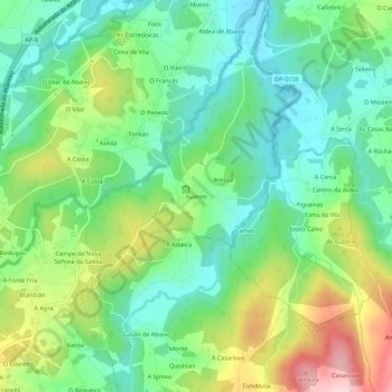
Name: Xuanzo topographic map, elevation, terrain.

Location: Xuanzo, Cullergondo, Abegondo, A Coruña, Galicia, 15389, Spain (43.19191 -8.26789 43.23191 -8.22789)

Average elevation: 427 ft

Minimum elevation: 161 ft

Maximum elevation: 945 ft

Other topographic maps

Click on a map to view its topography, its elevation and its terrain.

A Coruña

Spain > Galicia > A Coruña

Average elevation: 167 ft

A Coruña

Spain > Galicia > A Coruña

Average elevation: 167 ft

A Coruña

Spain > Galicia > A Coruña

Average elevation: 167 ft

Abegondo

Spain > Galicia > A Coruña

Average elevation: 650 ft

Tabeaio

Spain > Galicia > A Coruña

Average elevation: 515 ft

Carral

Spain > Galicia > A Coruña

Average elevation: 814 ft

A Coruña

Spain > Galicia > A Coruña

Average elevation: 167 ft

A Coruña

Spain > Galicia > A Coruña

Average elevation: 167 ft

Gear up for your next adventure:

🎒Trekking Poles - Sturdy poles for balance and stability on rough terrain
🌎3D Topographic Globes - Raised relief globes for a tactile understanding of geography
🏔️Mountain Trail Maps - High‑detail maps for popular peaks
📦Dry Bags Set - Waterproof storage for electronics and clothes
🧭Outdoor Navigation Book - Learn advanced navigation skills

As an Amazon Associate, this site earns from qualifying purchases at no extra cost to you.