Geolocate

Tabeaio topographic map

Click on the map to display elevation.

About this map

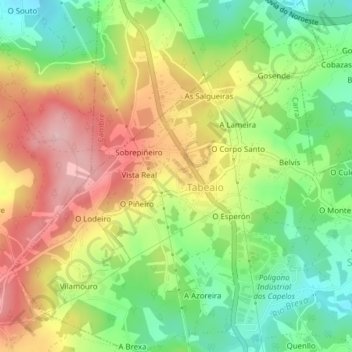
Name: Tabeaio topographic map, elevation, terrain.

Location: Tabeaio, Carral, A Coruña, Galicia, 15182, Spain (43.23510 -8.38072 43.26323 -8.34657)

Average elevation: 515 ft

Minimum elevation: 217 ft

Maximum elevation: 853 ft

Other topographic maps

Click on a map to view its topography, its elevation and its terrain.

Punta Torrella

Spain > Galicia > A Coruña

Average elevation: 59 ft

O Porto de Santa Cruz

Spain > Galicia > A Coruña

Average elevation: 131 ft

Xuanzo

Spain > Galicia > A Coruña

Average elevation: 427 ft

Monte Xalo

Spain > Galicia > A Coruña

Average elevation: 1,115 ft

Salgueiros

Spain > Galicia > A Coruña > Quembre

Average elevation: 787 ft

Oleiros

Spain > Galicia > A Coruña

Average elevation: 236 ft

Gear up for your next adventure:

📦Dry Bags Set - Waterproof storage for electronics and clothes
🪶Compact Camp Shovel - Folding shovel for campsite tasks
🔭Telescopic Hiking Pole - Adjustable pole for hiking stability
🎁Geography Themed Gifts - Unique gift ideas for map lovers and geography enthusiasts
🪶Camp Gear Gift Set - Perfect gift bundle for outdoor fans

As an Amazon Associate, this site earns from qualifying purchases at no extra cost to you.