
Make a donation
Gear up for your next adventure:
As an Amazon Associate, this site earns from qualifying purchases at no extra cost to you.
Tiout topographic map
Click on the map to display elevation.
Make a donation
Gear up for your next adventure:
As an Amazon Associate, this site earns from qualifying purchases at no extra cost to you.
Tiout
Tiout is located 40 km from the thermal station Ain Ouarka, 45 km from the tower (qalaa) of Chikh Bouamama, 40 km from Sfessefa, 70 km from Boussemghoun, and 50 km from Aasla. It has an average altitude of 1000m. Tiout covers an area of 789.25 km² and counts at the end of 2008 a population of 6657 inhabitants. The area is famous for its rock carvings. It has more than 54 stations.
Make a donation
Gear up for your next adventure:
As an Amazon Associate, this site earns from qualifying purchases at no extra cost to you.
About this map
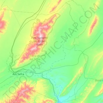
Name: Tiout topographic map, elevation, terrain.
Location: Tiout, Aïn Séfra District, Naâma, 45210, Algeria (32.63584 -0.52172 33.06435 -0.22508)
Average elevation: 4,078 ft
Minimum elevation: 3,051 ft
Maximum elevation: 7,270 ft
Make a donation
Gear up for your next adventure:
As an Amazon Associate, this site earns from qualifying purchases at no extra cost to you.