
Rockingham topographic map
Click on the map to display elevation.
Rockingham
Rockingham is topographically flat, has sandy soils and coastal vegetation. It has a northern aspect to Cockburn Sound, from Rockingham Beach and Palm Beach.
About this map
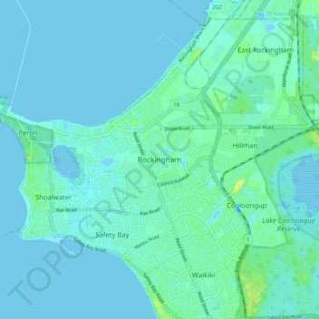
Name: Rockingham topographic map, elevation, terrain.
Location: Rockingham, Western Australia, 6168, Australia (-32.32519 115.70265 -32.24519 115.78265)
Average elevation: 13 ft
Minimum elevation: -13 ft
Maximum elevation: 66 ft
Other topographic maps
Click on a map to view its topography, its elevation and its terrain.