
Make a donation
Gear up for your next adventure:
As an Amazon Associate, this site earns from qualifying purchases at no extra cost to you.
Marmanet topographic map
Click on the map to display elevation.
Make a donation
Gear up for your next adventure:
As an Amazon Associate, this site earns from qualifying purchases at no extra cost to you.
About this map
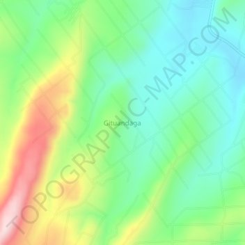
Name: Marmanet topographic map, elevation, terrain.
Location: Marmanet, Laikipia West, Laikipia County, Rift Valley, Kenya (0.14668 36.29660 0.18668 36.33660)
Average elevation: 7,631 ft
Minimum elevation: 7,241 ft
Maximum elevation: 8,383 ft
Make a donation
Gear up for your next adventure:
As an Amazon Associate, this site earns from qualifying purchases at no extra cost to you.
Other topographic maps
Click on a map to view its topography, its elevation and its terrain.
Nyahururu
Kenya > Laikipia County > Laikipia West
Nyahururu is also frequented by marathon and cross-country runners for practicing before major events due to its high altitude.
Average elevation: 7,703 ft
Nyahururu
Kenya > Laikipia County > Laikipia West
Nyahururu is also frequented by marathon and cross-country runners for practicing before major events due to its high altitude.
Average elevation: 7,703 ft