
Make a donation
Gear up for your next adventure:
As an Amazon Associate, this site earns from qualifying purchases at no extra cost to you.
Helchteren topographic map
Click on the map to display elevation.
Make a donation
Gear up for your next adventure:
As an Amazon Associate, this site earns from qualifying purchases at no extra cost to you.
Helchteren
Helchteren is gelegen op het Kempens Plateau en heeft een hoogte van 70 à 80 m. De Mangelbeek stroomt ten zuiden van Helchteren van het plateau af in westelijke richting. Een deel van de heidegebieden, met name de Donderslagse Heide en de aansluitende Sonnisheide, vormt een uitgestrekt militair schietterrein.
Make a donation
Gear up for your next adventure:
As an Amazon Associate, this site earns from qualifying purchases at no extra cost to you.
About this map
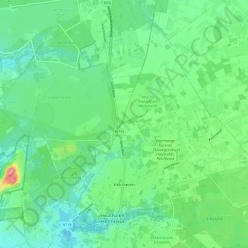
Name: Helchteren topographic map, elevation, terrain.
Average elevation: 223 ft
Minimum elevation: 135 ft
Maximum elevation: 466 ft
Make a donation
Gear up for your next adventure:
As an Amazon Associate, this site earns from qualifying purchases at no extra cost to you.
Other topographic maps
Click on a map to view its topography, its elevation and its terrain.
Houthalen-Oost
België > Limburg > Maaseik > Houthalen-Helchteren > Houthalen
Average elevation: 256 ft