Geolocate

Gaisberg topographic map

Click on the map to display elevation.

About this map

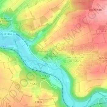
Name: Gaisberg topographic map, elevation, terrain.

Location: Gaisberg, Kirchberg an der Murr, Vereinbarte Verwaltungsgemeinschaft der Stadt Backnang, Rems-Murr-Kreis, Baden-Württemberg, 71737, Deutschland (48.94402 9.33204 48.94412 9.33214)

Average elevation: 912 ft

Minimum elevation: 669 ft

Maximum elevation: 1,129 ft

Other topographic maps

Click on a map to view its topography, its elevation and its terrain.

Gear up for your next adventure:

🔭Stargazing Telescopes - Perfect for camping in low-light pollution areas shown on maps
🪓Survival Multi‑Tool - Versatile tool for camp and trail tasks
Camping Coffee Makers - Enjoy premium coffee at the summit or campsite
⛑️Personal Locator Beacon - Safety beacon for emergencies
🛠️Outdoor Gear Repair Kit - Essential tools to fix gear on the trail

As an Amazon Associate, this site earns from qualifying purchases at no extra cost to you.