Geolocate

Greccio topographic map

Click on the map to display elevation.

About this map

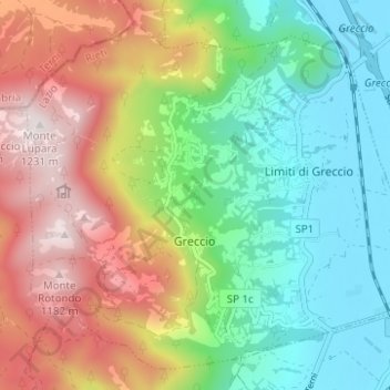
Name: Greccio topographic map, elevation, terrain.

Location: Greccio, Rieti, Lazio, 02045, Italy (42.42973 12.72505 42.47054 12.78704)

Average elevation: 2,310 ft

Minimum elevation: 1,217 ft

Maximum elevation: 4,006 ft

Other topographic maps

Click on a map to view its topography, its elevation and its terrain.

Monticchio

Italy > Lazio > Rieti > Monte San Giovanni in Sabina

Average elevation: 2,552 ft

Poggio Corese

Italy > Lazio > Rieti

Average elevation: 1,158 ft

Villanova

Italy > Lazio > Rieti > Accumoli

Average elevation: 3,415 ft

Pian de' Valli

Italy > Lazio > Rieti > Rieti > Pian de' Valli

Average elevation: 5,016 ft

Gear up for your next adventure:

🧼Biodegradable Camping Soap - Eco‑friendly soap for outdoor hygiene
👟Men's Trail Runners - Lightweight footwear for fast-paced exploration and light hiking
🌎3D Topographic Globes - Raised relief globes for a tactile understanding of geography
🦟Ultrasonic Repellers - Create a bug-free zone at your camp or rest stop
🔥Plasma Lighters - Windproof lighters that work in any weather condition

As an Amazon Associate, this site earns from qualifying purchases at no extra cost to you.