
Make a donation
Gear up for your next adventure:
As an Amazon Associate, this site earns from qualifying purchases at no extra cost to you.
Heiligenbronn topographic map
Click on the map to display elevation.
Make a donation
Gear up for your next adventure:
As an Amazon Associate, this site earns from qualifying purchases at no extra cost to you.
About this map
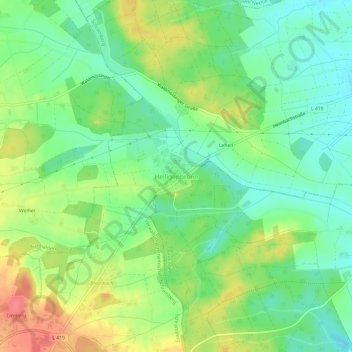
Name: Heiligenbronn topographic map, elevation, terrain.
Average elevation: 2,231 ft
Minimum elevation: 2,146 ft
Maximum elevation: 2,362 ft
Make a donation
Gear up for your next adventure:
As an Amazon Associate, this site earns from qualifying purchases at no extra cost to you.
Other topographic maps
Click on a map to view its topography, its elevation and its terrain.
Tennenbronn
Deutschland > Baden-Württemberg > Landkreis Rottweil > Schramberg
Tennenbronn liegt im Bernecktal südwestlich von Schramberg zwischen 460 und 943 m über dem Meeresspiegel. Die höchste Erhebung Tennenbronns und des Landkreises Rottweil ist die Brunnhölzer Höhe (943 m ü. M.). Der im Jahre 2006 zu Schramberg gekommene Ortsteil befindet sich am westlichen Zipfel des…
Average elevation: 2,523 ft
78713
Deutschland > Baden-Württemberg > Landkreis Rottweil > Schramberg > Lienberg
Average elevation: 2,211 ft
Waldmössingen
Deutschland > Baden-Württemberg > Landkreis Rottweil > Schramberg
Average elevation: 2,221 ft
Tennenbronn
Deutschland > Baden-Württemberg > Landkreis Rottweil > Schramberg
Tennenbronn liegt im Bernecktal südwestlich von Schramberg zwischen 460 und 943 m über dem Meeresspiegel. Die höchste Erhebung Tennenbronns und des Landkreises Rottweil ist die Brunnhölzer Höhe (943 m ü. M.). Der im Jahre 2006 zu Schramberg gekommene Ortsteil befindet sich am westlichen Zipfel des…
Average elevation: 2,523 ft
Make a donation
Gear up for your next adventure:
As an Amazon Associate, this site earns from qualifying purchases at no extra cost to you.