
Thank you for supporting this site ❤️
Make a donation
Make a donation
Gear up for your next adventure:
As an Amazon Associate, this site earns from qualifying purchases at no extra cost to you.
Nujvi/Nulvi topographic map
Click on the map to display elevation.
Thank you for supporting this site ❤️
Make a donation
Make a donation
Gear up for your next adventure:
As an Amazon Associate, this site earns from qualifying purchases at no extra cost to you.
About this map
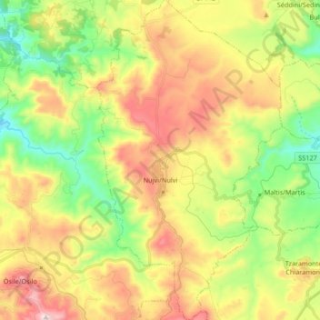
Name: Nujvi/Nulvi topographic map, elevation, terrain.
Location: Nujvi/Nulvi, Sassari, Sardinia, 07032, Italy (40.72863 8.71069 40.85400 8.80683)
Average elevation: 1,211 ft
Minimum elevation: 236 ft
Maximum elevation: 2,474 ft
Thank you for supporting this site ❤️
Make a donation
Make a donation
Gear up for your next adventure:
As an Amazon Associate, this site earns from qualifying purchases at no extra cost to you.
Other topographic maps
Click on a map to view its topography, its elevation and its terrain.