
Thank you for supporting this site ❤️
Make a donation
Make a donation
Gear up for your next adventure:
As an Amazon Associate, this site earns from qualifying purchases at no extra cost to you.
Boussu topographic map
Click on the map to display elevation.
Thank you for supporting this site ❤️
Make a donation
Make a donation
Gear up for your next adventure:
As an Amazon Associate, this site earns from qualifying purchases at no extra cost to you.
About this map
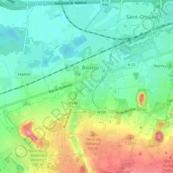
Name: Boussu topographic map, elevation, terrain.
Location: Boussu, Mons, Hainaut, Wallonia, 7300, Belgium (50.40263 3.75826 50.45250 3.81548)
Average elevation: 151 ft
Minimum elevation: 43 ft
Maximum elevation: 374 ft
Thank you for supporting this site ❤️
Make a donation
Make a donation
Gear up for your next adventure:
As an Amazon Associate, this site earns from qualifying purchases at no extra cost to you.