Geolocate

Tinitian topographic map

Click on the map to display elevation.

👉 Easily get elevation data in JSON, GeoTIFF and KML formats using Elevation API
Thank you for supporting this site ❤️
Make a donation

About this map

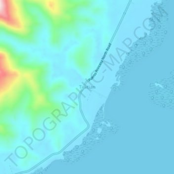
Name: Tinitian topographic map, elevation, terrain.

Location: Tinitian, Roxas, Palawan, Mimaropa, Philippines (10.04478 119.17913 10.08478 119.21913)

Average elevation: 138 ft

Minimum elevation: -7 ft

Maximum elevation: 1,224 ft

Other topographic maps

Click on a map to view its topography, its elevation and its terrain.

Long Beach

Philippines > Palawan > Roxas > San Isidro

Average elevation: 13 ft

Purao Island

Philippines > Palawan > Roxas

Average elevation: 0 ft

Stanlake Island

Philippines > Palawan > Roxas

Average elevation: 0 ft

Coconut Beach

Philippines > Palawan > Roxas

Average elevation: 75 ft

Boayan

Philippines > Palawan > Roxas

Average elevation: 39 ft

Gear up for your next adventure:

🗺️NatGeo Topo Maps - High-quality waterproof printed topographic maps of US Parks
🎒Trekking Poles - Sturdy poles for balance and stability on rough terrain
👖Convertible Hiking Pants - Versatile zip-off pants for changing altitudes and temperatures
Camping Coffee Makers - Enjoy premium coffee at the summit or campsite
📚USA Hiking Guide Books - Top trail guides and map books

As an Amazon Associate, this site earns from qualifying purchases at no extra cost to you.