
Thank you for supporting this site ❤️
Make a donation
Make a donation
Gear up for your next adventure:
As an Amazon Associate, this site earns from qualifying purchases at no extra cost to you.
Aksy topographic map
Click on the map to display elevation.
Thank you for supporting this site ❤️
Make a donation
Make a donation
Gear up for your next adventure:
As an Amazon Associate, this site earns from qualifying purchases at no extra cost to you.
About this map
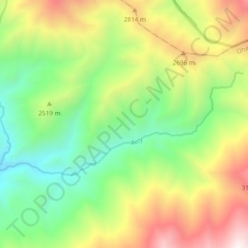
Name: Aksy topographic map, elevation, terrain.
Location: Aksy, Ohangaron Tumani, Tashkent Region, Uzbekistan (41.19959 70.17084 41.22052 70.23796)
Average elevation: 8,133 ft
Minimum elevation: 6,115 ft
Maximum elevation: 11,191 ft
Thank you for supporting this site ❤️
Make a donation
Make a donation
Gear up for your next adventure:
As an Amazon Associate, this site earns from qualifying purchases at no extra cost to you.