
Make a donation
Gear up for your next adventure:
As an Amazon Associate, this site earns from qualifying purchases at no extra cost to you.
Rivadavia topographic map
Click on the map to display elevation.
Make a donation
Gear up for your next adventure:
As an Amazon Associate, this site earns from qualifying purchases at no extra cost to you.
Rivadavia
Morfológicamente, la ciudad cuenta con un paisaje chato de viviendas bajas que no superan los 2 niveles, siendo escasas las estructuras que resaltan por su altitud. Las más importantes son el edificio municipal (4 pisos), la galería Centorbi (6 pisos), la torre de la Iglesia San Isidro Labrador y el tanque de agua.
Make a donation
Gear up for your next adventure:
As an Amazon Associate, this site earns from qualifying purchases at no extra cost to you.
About this map
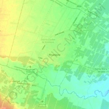
Name: Rivadavia topographic map, elevation, terrain.
Average elevation: 2,172 ft
Minimum elevation: 2,119 ft
Maximum elevation: 2,238 ft
Make a donation
Gear up for your next adventure:
As an Amazon Associate, this site earns from qualifying purchases at no extra cost to you.