Geolocate

Grossbasel topographic map

Click on the map to display elevation.

About this map

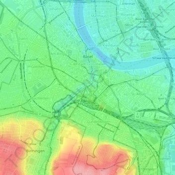
Name: Grossbasel topographic map, elevation, terrain.

Location: Grossbasel, Basel, Basel-City, 4002, Switzerland (47.53097 7.56777 47.57097 7.60777)

Average elevation: 932 ft

Minimum elevation: 797 ft

Maximum elevation: 1,188 ft

Other topographic maps

Click on a map to view its topography, its elevation and its terrain.

Claramatte

Switzerland > Basel-City > Basel

Average elevation: 866 ft

Grossbasel

Switzerland > Basel-City > Basel

Average elevation: 945 ft

Grossbasel

Switzerland > Basel-City > Basel

Average elevation: 945 ft

Gear up for your next adventure:

Camping Coffee Makers - Enjoy premium coffee at the summit or campsite
📶Vehicle Signal Boosters - Improve reception in rural areas while driving to trailheads
🧥Waterproof Jacket for Hiking - Breathable and rugged rain jacket for outdoor excursions
🩳Quick‑Dry Hiking Shorts - Comfortable and quick‑dry shorts for summer hiking
🔋Rechargeable Batteries - Power up your outdoor devices

As an Amazon Associate, this site earns from qualifying purchases at no extra cost to you.