
Make a donation
Gear up for your next adventure:
As an Amazon Associate, this site earns from qualifying purchases at no extra cost to you.
Cherbourg-Octeville topographic map
Click on the map to display elevation.
Make a donation
Gear up for your next adventure:
As an Amazon Associate, this site earns from qualifying purchases at no extra cost to you.
About this map
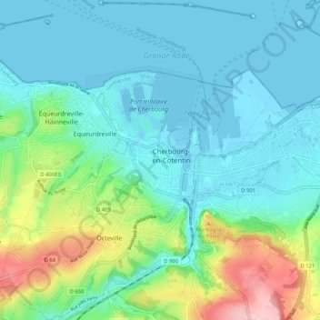
Name: Cherbourg-Octeville topographic map, elevation, terrain.
Average elevation: 128 ft
Minimum elevation: -23 ft
Maximum elevation: 568 ft
Make a donation
Gear up for your next adventure:
As an Amazon Associate, this site earns from qualifying purchases at no extra cost to you.
Other topographic maps
Click on a map to view its topography, its elevation and its terrain.
Le Becquet de Tourlaville
France > Normandie > Manche > Cherbourg-en-Cotentin
Average elevation: 105 ft
Make a donation
Gear up for your next adventure:
As an Amazon Associate, this site earns from qualifying purchases at no extra cost to you.
Le Becquet de Digosville
France > Normandie > Manche > Cherbourg-en-Cotentin
Average elevation: 105 ft
Hameau Saint-Jean
France > Normandie > Manche > Cherbourg-en-Cotentin > Hameau Saint-Jean
Average elevation: 302 ft
Make a donation
Gear up for your next adventure:
As an Amazon Associate, this site earns from qualifying purchases at no extra cost to you.
Ouvrage Saint-Gabriel
France > Normandie > Manche > Cherbourg-en-Cotentin > Les Charmettes
Average elevation: 295 ft