
Weilerswist topographic map
Click on the map to display elevation.
Weilerswist
Weilerswist liegt zwischen der Zülpicher Börde und dem Vorgebirge, am südwestlichen Rand der Ville, eines Höhenzuges der Kölner Bucht. Durch das Gemeindegebiet fließen im Osten die Swist und im Westen die Erft, die in Weilerswist von vier kleineren Nebengewässern gespeist werden. Im Norden grenzt die Gemeinde an die Städte Brühl und Erftstadt (beide im Rhein-Erft-Kreis), im Osten an die Stadt Bornheim und die Gemeinde Swisttal (beide im Rhein-Sieg-Kreis), im Süden an die Kreisstadt Euskirchen sowie im Westen an die Stadt Zülpich (ebenfalls im Kreis Euskirchen).
About this map
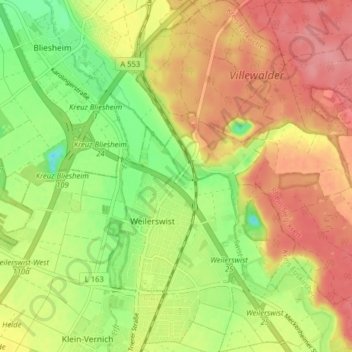
Name: Weilerswist topographic map, elevation, terrain.
Location: Weilerswist, Kreis Euskirchen, Nordrhein-Westfalen, Deutschland (50.73937 6.80710 50.78964 6.87311)
Average elevation: 423 ft
Minimum elevation: 269 ft
Maximum elevation: 551 ft
Other topographic maps
Click on a map to view its topography, its elevation and its terrain.
Bodenheim
Deutschland > Nordrhein-Westfalen > Kreis Euskirchen > Weilerswist
Average elevation: 489 ft