
Make a donation
Gear up for your next adventure:
As an Amazon Associate, this site earns from qualifying purchases at no extra cost to you.
Tihău topographic map
Click on the map to display elevation.
Make a donation
Gear up for your next adventure:
As an Amazon Associate, this site earns from qualifying purchases at no extra cost to you.
About this map
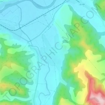
Name: Tihău topographic map, elevation, terrain.
Location: Tihău, Surduc, Sălaj, 457321, Romania (47.20656 23.30945 47.24656 23.34945)
Average elevation: 820 ft
Minimum elevation: 597 ft
Maximum elevation: 1,608 ft
Make a donation
Gear up for your next adventure:
As an Amazon Associate, this site earns from qualifying purchases at no extra cost to you.
Other topographic maps
Click on a map to view its topography, its elevation and its terrain.
Treznea
The commune is situated in the foothills of the Meseș Mountains, at an altitude of 304 m (997 ft), on the banks of the river Treznea. It is located in the central-south part of Sălaj County, at a distance of 14 km (8.7 mi) from the county seat, Zalău.
Average elevation: 1,263 ft
Zalău
The city includes a total surface of 90.09 km2 (34.78 sq mi). This includes the one village it administers, Stâna (Felsőnyárló), situated south-east of Meseș, in the hydrographic basin of the Agrij River. Măgura Stânii is at an altitude of 716 m (2,349 ft).
Average elevation: 1,040 ft
Make a donation
Gear up for your next adventure:
As an Amazon Associate, this site earns from qualifying purchases at no extra cost to you.
Make a donation
Gear up for your next adventure:
As an Amazon Associate, this site earns from qualifying purchases at no extra cost to you.
Zalău
The city includes a total surface of 90.09 km2 (34.78 sq mi). This includes the one village it administers, Stâna (Felsőnyárló), situated south-east of Meseș, in the hydrographic basin of the Agrij River. Măgura Stânii is at an altitude of 716 m (2,349 ft).
Average elevation: 1,135 ft
Make a donation
Gear up for your next adventure:
As an Amazon Associate, this site earns from qualifying purchases at no extra cost to you.
Make a donation
Gear up for your next adventure:
As an Amazon Associate, this site earns from qualifying purchases at no extra cost to you.