Geolocate

Thornton topographic map

Click on the map to display elevation.

About this map

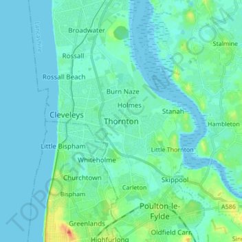
Name: Thornton topographic map, elevation, terrain.

Location: Thornton, Borough of Wyre, Lancashire, England, FY5 4AF, United Kingdom (53.83592 -3.05220 53.91592 -2.97220)

Average elevation: 23 ft

Minimum elevation: -3 ft

Maximum elevation: 128 ft

Other topographic maps

Click on a map to view its topography, its elevation and its terrain.

River Brock

United Kingdom > England > Lancashire > Borough of Wyre

Average elevation: 364 ft

Garstang

United Kingdom > England > Lancashire > Borough of Wyre

Average elevation: 79 ft

Nateby

United Kingdom > England > Lancashire > Borough of Wyre

Average elevation: 43 ft

Pilling

United Kingdom > England > Lancashire > Borough of Wyre > Pilling

Average elevation: 16 ft

Hambleton

United Kingdom > England > Lancashire > Borough of Wyre

Average elevation: 30 ft

Forton

United Kingdom > England > Lancashire > Borough of Wyre > Forton

Average elevation: 112 ft

Gear up for your next adventure:

🗃️Trail First Aid Kit - Essential kit for outdoor injuries and emergencies
🥄Camping Utensil Set - Lightweight utensils for outdoor meals
📡Handheld GPS Device - Reliable handheld GPS for outdoor navigation
🧢Outdoor Hiking Hat - Sun protection hat for outdoor explorers
📚USA Hiking Guide Books - Top trail guides and map books

As an Amazon Associate, this site earns from qualifying purchases at no extra cost to you.