
Make a donation
Gear up for your next adventure:
As an Amazon Associate, this site earns from qualifying purchases at no extra cost to you.
Calcena topographic map
Click on the map to display elevation.
Make a donation
Gear up for your next adventure:
As an Amazon Associate, this site earns from qualifying purchases at no extra cost to you.
Calcena
Rodeado de montañas se sitúa en la vertiente sur del Somontano del Moncayo a 836 m de altitud, en el valle del río Isuela. El casco urbano se encarama desde la orilla izquierda de dicho río hacia las cumbres de San José y Santa Bárbara. La huerta ocupa la parte baja del valle. Las malas comunicaciones han permitido conservar el sabor tradicional del casco urbano y la belleza de su entorno natural. Parte de su término municipal está ocupado por el parque natural del Moncayo.
Make a donation
Gear up for your next adventure:
As an Amazon Associate, this site earns from qualifying purchases at no extra cost to you.
About this map
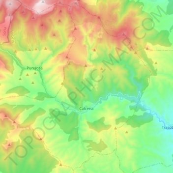
Name: Calcena topographic map, elevation, terrain.
Location: Calcena, Aranda, Zaragoza, Aragón, España (41.61409 -1.81311 41.72537 -1.65955)
Average elevation: 3,468 ft
Minimum elevation: 2,123 ft
Maximum elevation: 5,653 ft
Make a donation
Gear up for your next adventure:
As an Amazon Associate, this site earns from qualifying purchases at no extra cost to you.
Other topographic maps
Click on a map to view its topography, its elevation and its terrain.