
Thank you for supporting this site ❤️
Make a donation
Make a donation
Gear up for your next adventure:
As an Amazon Associate, this site earns from qualifying purchases at no extra cost to you.
Huacalle topographic map
Click on the map to display elevation.
Thank you for supporting this site ❤️
Make a donation
Make a donation
Gear up for your next adventure:
As an Amazon Associate, this site earns from qualifying purchases at no extra cost to you.
About this map
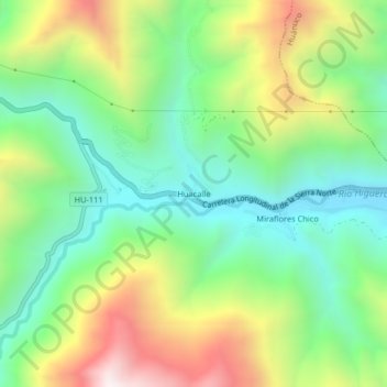
Name: Huacalle topographic map, elevation, terrain.
Location: Huacalle, Quisqui, Huánuco, Perú (-9.94315 -76.37134 -9.90315 -76.33134)
Average elevation: 7,972 ft
Minimum elevation: 6,634 ft
Maximum elevation: 10,276 ft
Thank you for supporting this site ❤️
Make a donation
Make a donation
Gear up for your next adventure:
As an Amazon Associate, this site earns from qualifying purchases at no extra cost to you.