Geolocate

Severn topographic map

Click on the map to display elevation.

About this map

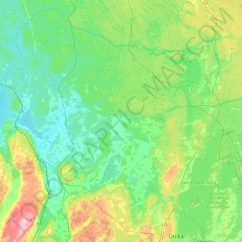
Name: Severn topographic map, elevation, terrain.

Location: Severn, Simcoe County, Central Ontario, Ontario, Canada (44.61214 -79.72320 44.89709 -79.29320)

Average elevation: 728 ft

Minimum elevation: 564 ft

Maximum elevation: 1,198 ft

Other topographic maps

Click on a map to view its topography, its elevation and its terrain.

Mad River

Canada > Ontario > Simcoe County > Springwater

Average elevation: 600 ft

Anten Mills

Canada > Ontario > Simcoe County > Springwater

Average elevation: 719 ft

Brechin

Canada > Ontario > Simcoe County > Ramara Township

Average elevation: 751 ft

Elmvale

Canada > Ontario > Simcoe County > Springwater > Elmvale

Average elevation: 735 ft

Collingwood

Canada > Ontario > Simcoe County > Collingwood

Average elevation: 617 ft

Dunedin

Canada > Ontario > Simcoe County > Clearview

Average elevation: 1,322 ft

Gear up for your next adventure:

🌡️Handheld Weather Meters - Measure wind, temp, and pressure for safe mountain travel
🧼Biodegradable Camping Soap - Eco‑friendly soap for outdoor hygiene
🛰️Handheld GPS Units - Professional satellite navigators for precise backcountry mapping
🧦Hiking Socks - Comfortable socks to prevent blisters on long hikes
🔋Solar Power Banks - Keep your GPS and phone charged in remote wilderness areas

As an Amazon Associate, this site earns from qualifying purchases at no extra cost to you.