
Thank you for supporting this site ❤️
Make a donation
Make a donation
Gear up for your next adventure:
As an Amazon Associate, this site earns from qualifying purchases at no extra cost to you.
Sanglia topographic map
Click on the map to display elevation.
Thank you for supporting this site ❤️
Make a donation
Make a donation
Gear up for your next adventure:
As an Amazon Associate, this site earns from qualifying purchases at no extra cost to you.
About this map
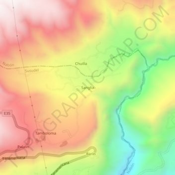
Name: Sanglia topographic map, elevation, terrain.
Location: Sanglia, Susudel, Oña, Azuay, Ecuador (-3.39835 -79.18363 -3.35835 -79.14363)
Average elevation: 8,235 ft
Minimum elevation: 6,316 ft
Maximum elevation: 9,803 ft
Thank you for supporting this site ❤️
Make a donation
Make a donation
Gear up for your next adventure:
As an Amazon Associate, this site earns from qualifying purchases at no extra cost to you.