
Thank you for supporting this site ❤️
Make a donation
Make a donation
Gear up for your next adventure:
As an Amazon Associate, this site earns from qualifying purchases at no extra cost to you.
Malandruge topographic map
Click on the map to display elevation.
Thank you for supporting this site ❤️
Make a donation
Make a donation
Gear up for your next adventure:
As an Amazon Associate, this site earns from qualifying purchases at no extra cost to you.
About this map
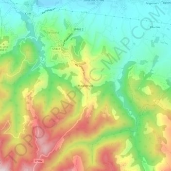
Name: Malandruge topographic map, elevation, terrain.
Location: Malandruge, Bettona, Perugia, Umbria, 06084, Italy (42.98116 12.47521 43.02116 12.51521)
Average elevation: 1,152 ft
Minimum elevation: 574 ft
Maximum elevation: 1,995 ft
Thank you for supporting this site ❤️
Make a donation
Make a donation
Gear up for your next adventure:
As an Amazon Associate, this site earns from qualifying purchases at no extra cost to you.