Geolocate

Santa Flavia topographic map

Click on the map to display elevation.

About this map

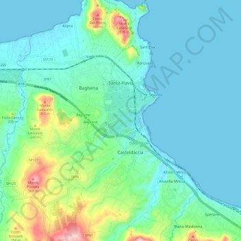
Name: Santa Flavia topographic map, elevation, terrain.

Location: Santa Flavia, Palermo, Sicily, 90017, Italy (38.01927 13.47981 38.11373 13.54416)

Average elevation: 266 ft

Minimum elevation: 0 ft

Maximum elevation: 1,375 ft

Other topographic maps

Click on a map to view its topography, its elevation and its terrain.

Sorgente di Montescuro

Italy > Sicily > Palermo > Prizzi

Average elevation: 2,726 ft

Bellacera

Italy > Sicily > Palermo > Santa Flavia

Average elevation: 531 ft

Finale

Italy > Sicily > Palermo

Average elevation: 276 ft

Santa Lucia

Italy > Sicily > Palermo > Cefalù

Average elevation: 167 ft

San Carlo

Italy > Sicily > Palermo > Chiusa Sclafani

Average elevation: 955 ft

Gear up for your next adventure:

🪶Paracord Bracelet - Survival bracelet with built‑in tools
🩳Quick‑Dry Hiking Shorts - Comfortable and quick‑dry shorts for summer hiking
🌡️Portable Weather Meter - Track weather conditions on the trail
🌎3D Topographic Globes - Raised relief globes for a tactile understanding of geography
🏥Hiking First Aid Kits - Comprehensive medical kits for remote trail injuries

As an Amazon Associate, this site earns from qualifying purchases at no extra cost to you.