
Make a donation
Gear up for your next adventure:
As an Amazon Associate, this site earns from qualifying purchases at no extra cost to you.
Gambela topographic map
Click on the map to display elevation.
Make a donation
Gear up for your next adventure:
As an Amazon Associate, this site earns from qualifying purchases at no extra cost to you.
Gambela
Gambela (Amharic: ጋምቤላ), also spelled Gambella, is a city and separate woreda in Ethiopia and the capital of the Gambela Region. Located in Anyuak Zone, at the confluence of the Baro River and its tributary the Jajjabe, the city has a latitude and longitude of 8°15′N 34°35′E / 8.250°N 34.583°E / 8.250; 34.583 and an elevation of 526 meters. It is surrounded by Gambella Zuria.
Make a donation
Gear up for your next adventure:
As an Amazon Associate, this site earns from qualifying purchases at no extra cost to you.
About this map
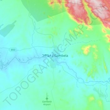
Name: Gambela topographic map, elevation, terrain.
Location: Gambela, Agnuak, Gambela Region, Ethiopia (8.09037 34.42773 8.41037 34.74773)
Average elevation: 1,870 ft
Minimum elevation: 1,407 ft
Maximum elevation: 4,692 ft
Make a donation
Gear up for your next adventure:
As an Amazon Associate, this site earns from qualifying purchases at no extra cost to you.
Other topographic maps
Click on a map to view its topography, its elevation and its terrain.