
Make a donation
Gear up for your next adventure:
As an Amazon Associate, this site earns from qualifying purchases at no extra cost to you.
Nilakkottai topographic map
Click on the map to display elevation.
Make a donation
Gear up for your next adventure:
As an Amazon Associate, this site earns from qualifying purchases at no extra cost to you.
Nilakkottai
Nilakkottai is located at 10°10′N 77°51′E / 10.17°N 77.85°E / 10.17; 77.85. It has an average elevation of 320 metres (1049 feet).
Make a donation
Gear up for your next adventure:
As an Amazon Associate, this site earns from qualifying purchases at no extra cost to you.
About this map
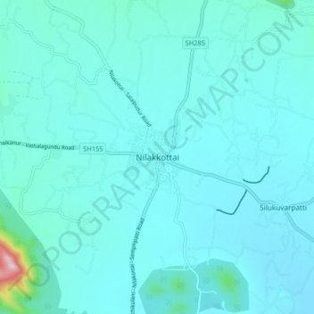
Name: Nilakkottai topographic map, elevation, terrain.
Location: Nilakkottai, Dindigul, Tamil Nadu, 624208, India (10.12483 77.81285 10.20483 77.89285)
Average elevation: 794 ft
Minimum elevation: 653 ft
Maximum elevation: 2,251 ft
Make a donation
Gear up for your next adventure:
As an Amazon Associate, this site earns from qualifying purchases at no extra cost to you.