Geolocate

T2 topographic map

Click on the map to display elevation.

About this map

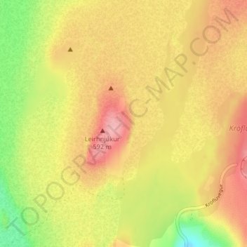
Name: T2 topographic map, elevation, terrain.

Location: T2, Þingeyjarsveit, Northeastern Region, Iceland (65.72196 -16.78784 65.72206 -16.78774)

Average elevation: 1,785 ft

Minimum elevation: 1,575 ft

Maximum elevation: 1,936 ft

Other topographic maps

Click on a map to view its topography, its elevation and its terrain.

Mývatn

Iceland > Þingeyjarsveit > Reykjahlíð

Average elevation: 935 ft

Stakhólstjörn

Iceland > Þingeyjarsveit

Average elevation: 919 ft

Skútustaðagígar

Iceland > Þingeyjarsveit

Average elevation: 919 ft

Gear up for your next adventure:

🦺Reflective Outdoor Gear - Safety gear for low‑light conditions
🗺️Topographic Maps - Detailed topo maps for hiking, exploring and outdoor navigation
👟Trail Running Shoes - Lightweight shoes for trail runners
📷Action Camera - Capture your outdoor adventures in HD
🧤Hiking Gloves - Protective gloves for rugged trails

As an Amazon Associate, this site earns from qualifying purchases at no extra cost to you.