
Make a donation
Gear up for your next adventure:
As an Amazon Associate, this site earns from qualifying purchases at no extra cost to you.
Kussow topographic map
Click on the map to display elevation.
Make a donation
Gear up for your next adventure:
As an Amazon Associate, this site earns from qualifying purchases at no extra cost to you.
About this map
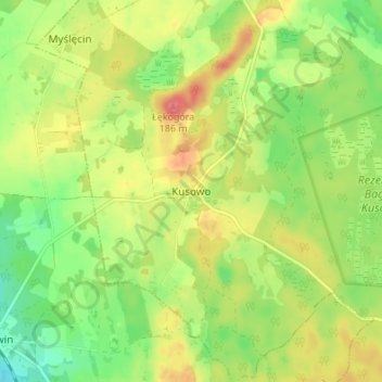
Name: Kussow topographic map, elevation, terrain.
Average elevation: 479 ft
Minimum elevation: 374 ft
Maximum elevation: 597 ft
Make a donation
Gear up for your next adventure:
As an Amazon Associate, this site earns from qualifying purchases at no extra cost to you.
Other topographic maps
Click on a map to view its topography, its elevation and its terrain.
Neustettin
Polen > Woiwodschaft Westpommern > powiat szczecinecki
Die Stadt liegt in Hinterpommern, im Zentrum der Draheimer Seenplatte (Pojezierze Drawskie), in einer Höhe von 135 m über dem Meeresniveau, etwa 60 km südsüdöstlich von Köslin (Koszalin) und 140 km ostnordöstlich von Stettin.
Average elevation: 479 ft