Geolocate

Kariango topographic map

Click on the map to display elevation.

About this map

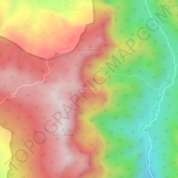
Name: Kariango topographic map, elevation, terrain.

Location: Kariango, Pinrang, South Sulawesi, Sulawesi, Indonesia (-3.54524 119.65472 -3.50524 119.69472)

Average elevation: 2,887 ft

Minimum elevation: 1,158 ft

Maximum elevation: 4,291 ft

Other topographic maps

Click on a map to view its topography, its elevation and its terrain.

Gear up for your next adventure:

🛡️Bear Spray Outdoor - Protection in bear country hikes
🌧️Backpack Rain Cover - Keep gear dry in wet weather
🔦Powerful Headlamps - Ultra-bright hands-free lighting for night navigation
🕶️GPS Smartphone Mount - Secure mount for phone navigation
🧼Biodegradable Camping Soap - Eco‑friendly soap for outdoor hygiene

As an Amazon Associate, this site earns from qualifying purchases at no extra cost to you.