
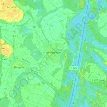
Leimersheim topographic map
Interactive map
Click on the map to display elevation.
About this map
Name: Leimersheim topographic map, elevation, terrain.
Average elevation: 331 ft
Minimum elevation: 305 ft
Maximum elevation: 374 ft
Leimersheim liegt im mittleren Oberrheingraben im Bereich der linksseitigen Niederterrassen des Rheins auf 100 m Höhe zwischen den Rheinbrücken von Germersheim und Karlsruhe. Das Ortsgebiet und den Rheinstrom trennt seit der Rheinbegradigung des 19. Jahrhunderts der Auwald, in dem diverse Altarme sowie ein Hochwasserschutzdamm verlaufen.
Other topographic maps
Click on a map to view its topography, its elevation and its terrain.
76771
Deutschland > Rheinland-Pfalz > Landkreis Germersheim > Hördt
76771, Hördt, Rülzheim, Landkreis Germersheim, Rheinland-Pfalz, Deutschland
Average elevation: 335 ft
Wörth am Rhein
Deutschland > Rheinland-Pfalz > Landkreis Germersheim
Wörth am Rhein, Landkreis Germersheim, Rheinland-Pfalz, 76744, Deutschland
Average elevation: 377 ft
Kandel
Deutschland > Rheinland-Pfalz > Landkreis Germersheim
Kandel, Landkreis Germersheim, Rheinland-Pfalz, Deutschland
Average elevation: 407 ft
Germersheim
Deutschland > Rheinland-Pfalz > Landkreis Germersheim
Germersheim, Landkreis Germersheim, Rheinland-Pfalz, 76726, Deutschland
Average elevation: 341 ft
Schaidt
Deutschland > Rheinland-Pfalz > Landkreis Germersheim > Wörth am Rhein
Schaidt, Wörth am Rhein, Landkreis Germersheim, Rheinland-Pfalz, Deutschland
Average elevation: 479 ft
Winden
Deutschland > Rheinland-Pfalz > Landkreis Germersheim
Winden, Kandel, Landkreis Germersheim, Rheinland-Pfalz, Deutschland
Average elevation: 479 ft
Jockgrim
Deutschland > Rheinland-Pfalz > Landkreis Germersheim
Jockgrim, Landkreis Germersheim, Rheinland-Pfalz, 76751, Deutschland
Average elevation: 358 ft
Maximiliansau
Deutschland > Rheinland-Pfalz > Landkreis Germersheim > Wörth am Rhein
Maximiliansau, Wörth am Rhein, Landkreis Germersheim, Rheinland-Pfalz, 76767, Deutschland
Average elevation: 348 ft
Hagenbach
Deutschland > Rheinland-Pfalz > Landkreis Germersheim
Hagenbach, Landkreis Germersheim, Rheinland-Pfalz, 76767, Deutschland
Average elevation: 361 ft
Bellheim
Deutschland > Rheinland-Pfalz > Landkreis Germersheim
Bellheim, Landkreis Germersheim, Rheinland-Pfalz, 76756, Deutschland
Average elevation: 390 ft
Schwegenheim
Deutschland > Rheinland-Pfalz > Landkreis Germersheim
Schwegenheim, Lingenfeld, Landkreis Germersheim, Rheinland-Pfalz, 67365, Deutschland
Average elevation: 377 ft
Berg (Pfalz)
Deutschland > Rheinland-Pfalz > Landkreis Germersheim > Berg (Pfalz)
Berg (Pfalz), Hagenbach, Landkreis Germersheim, Rheinland-Pfalz, 76768, Deutschland
Average elevation: 377 ft
Rheinzabern
Deutschland > Rheinland-Pfalz > Landkreis Germersheim
Rheinzabern, Jockgrim, Landkreis Germersheim, Rheinland-Pfalz, 76764, Deutschland
Average elevation: 367 ft
Westheim
Deutschland > Rheinland-Pfalz > Landkreis Germersheim
Westheim, Lingenfeld, Landkreis Germersheim, Rheinland-Pfalz, 67368, Deutschland
Average elevation: 374 ft
Hördt
Deutschland > Rheinland-Pfalz > Landkreis Germersheim
Hördt, Rülzheim, Landkreis Germersheim, Rheinland-Pfalz, 76771, Deutschland
Average elevation: 351 ft
Rülzheim
Deutschland > Rheinland-Pfalz > Landkreis Germersheim
Rülzheim, Landkreis Germersheim, Rheinland-Pfalz, 76761, Deutschland
Average elevation: 387 ft
Lingenfeld
Deutschland > Rheinland-Pfalz > Landkreis Germersheim
Lingenfeld, Landkreis Germersheim, Rheinland-Pfalz, 67360, Deutschland
Average elevation: 361 ft