Geolocate

Kandel topographic map

Interactive map

Click on the map to display elevation.

About this map

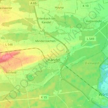
Name: Kandel topographic map, elevation, terrain.

Location: Kandel, Landkreis Germersheim, Rheinland-Pfalz, Deutschland (49.06042 8.13240 49.11060 8.25945)

Average elevation: 407 ft

Minimum elevation: 322 ft

Maximum elevation: 531 ft

Ursprünglich war Kandel ein für die Südpfalz typisches Straßendorf. Das eigentliche Stadtgebiet gliedert sich in verschiedene Teile: Oberkandel (westlicher Teil), Mittelkandel (mittlerer Teil) und Unterkandel (östlicher Teil). Wegen der Größe des langgestreckten Ortes war zeitweise auch die Bezeichnung Langenkandel üblich. Bereits vor dem Zweiten Weltkrieg entstand südlich der Innenstadt die sogenannte Gartenstadt, in der Nachkriegszeit kamen diverse Neubaugebiete hinzu. Seit Anfang 2006 läuft die Erschließung des Neubaugebiets „Am Höhenweg“.

Wikipedia (CC-BY-SA 3.0)

Other topographic maps

Click on a map to view its topography, its elevation and its terrain.

76771

Deutschland > Rheinland-Pfalz > Landkreis Germersheim > Hördt

76771, Hördt, Rülzheim, Landkreis Germersheim, Rheinland-Pfalz, Deutschland

Average elevation: 335 ft

Wörth am Rhein

Deutschland > Rheinland-Pfalz > Landkreis Germersheim

Wörth am Rhein, Landkreis Germersheim, Rheinland-Pfalz, 76744, Deutschland

Average elevation: 377 ft

Germersheim

Deutschland > Rheinland-Pfalz > Landkreis Germersheim

Germersheim, Landkreis Germersheim, Rheinland-Pfalz, 76726, Deutschland

Average elevation: 341 ft

Schaidt

Deutschland > Rheinland-Pfalz > Landkreis Germersheim > Wörth am Rhein

Schaidt, Wörth am Rhein, Landkreis Germersheim, Rheinland-Pfalz, Deutschland

Average elevation: 479 ft

Winden

Deutschland > Rheinland-Pfalz > Landkreis Germersheim

Winden, Kandel, Landkreis Germersheim, Rheinland-Pfalz, Deutschland

Average elevation: 479 ft

Jockgrim

Deutschland > Rheinland-Pfalz > Landkreis Germersheim

Jockgrim, Landkreis Germersheim, Rheinland-Pfalz, 76751, Deutschland

Average elevation: 358 ft

Maximiliansau

Deutschland > Rheinland-Pfalz > Landkreis Germersheim > Wörth am Rhein

Maximiliansau, Wörth am Rhein, Landkreis Germersheim, Rheinland-Pfalz, 76767, Deutschland

Average elevation: 348 ft

Leimersheim

Deutschland > Rheinland-Pfalz > Landkreis Germersheim

Leimersheim, Rülzheim, Landkreis Germersheim, Rheinland-Pfalz, 76774, Deutschland

Average elevation: 331 ft

Hagenbach

Deutschland > Rheinland-Pfalz > Landkreis Germersheim

Hagenbach, Landkreis Germersheim, Rheinland-Pfalz, 76767, Deutschland

Average elevation: 361 ft

Bellheim

Deutschland > Rheinland-Pfalz > Landkreis Germersheim

Bellheim, Landkreis Germersheim, Rheinland-Pfalz, 76756, Deutschland

Average elevation: 390 ft

Schwegenheim

Deutschland > Rheinland-Pfalz > Landkreis Germersheim

Schwegenheim, Lingenfeld, Landkreis Germersheim, Rheinland-Pfalz, 67365, Deutschland

Average elevation: 377 ft

Berg (Pfalz)

Deutschland > Rheinland-Pfalz > Landkreis Germersheim > Berg (Pfalz)

Berg (Pfalz), Hagenbach, Landkreis Germersheim, Rheinland-Pfalz, 76768, Deutschland

Average elevation: 377 ft

Rheinzabern

Deutschland > Rheinland-Pfalz > Landkreis Germersheim

Rheinzabern, Jockgrim, Landkreis Germersheim, Rheinland-Pfalz, 76764, Deutschland

Average elevation: 367 ft

Westheim

Deutschland > Rheinland-Pfalz > Landkreis Germersheim

Westheim, Lingenfeld, Landkreis Germersheim, Rheinland-Pfalz, 67368, Deutschland

Average elevation: 374 ft

Hördt

Deutschland > Rheinland-Pfalz > Landkreis Germersheim

Hördt, Rülzheim, Landkreis Germersheim, Rheinland-Pfalz, 76771, Deutschland

Average elevation: 351 ft

Rülzheim

Deutschland > Rheinland-Pfalz > Landkreis Germersheim

Rülzheim, Landkreis Germersheim, Rheinland-Pfalz, 76761, Deutschland

Average elevation: 387 ft

Lingenfeld

Deutschland > Rheinland-Pfalz > Landkreis Germersheim

Lingenfeld, Landkreis Germersheim, Rheinland-Pfalz, 67360, Deutschland

Average elevation: 361 ft