Geolocate

Frazer topographic map

Click on the map to display elevation.

About this map

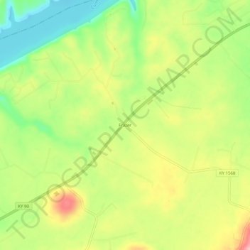
Name: Frazer topographic map, elevation, terrain.

Location: Frazer, Wayne County, Kentucky, United States (36.93646 -84.72494 36.97646 -84.68494)

Average elevation: 896 ft

Minimum elevation: 669 ft

Maximum elevation: 1,148 ft

Wayne County trails, hiking, mountain biking, running and outdoor activities

Other topographic maps

Click on a map to view its topography, its elevation and its terrain.

Monticello

United States > Kentucky > Wayne County

Average elevation: 997 ft

Monticello

United States > Kentucky > Wayne County

Average elevation: 997 ft

Gear up for your next adventure:

🧣Merino Neck Gaiters - Multi-functional headwear for wind and sun protection
🦺Reflective Outdoor Gear - Safety gear for low‑light conditions
🛰️Satellite Messengers - Emergency SOS and two-way messaging for off-grid adventures
🕶️Glacier Sunglasses - Side shields to protect eyes from high-altitude snow glare
🏫Relief Map Kits - Hands-on tools for teaching landforms and elevation

As an Amazon Associate, this site earns from qualifying purchases at no extra cost to you.