
Make a donation
Gear up for your next adventure:
As an Amazon Associate, this site earns from qualifying purchases at no extra cost to you.
Prnjavor topographic map
Click on the map to display elevation.
Make a donation
Gear up for your next adventure:
As an Amazon Associate, this site earns from qualifying purchases at no extra cost to you.
Prnjavor
The municipality is located in the basin of the Ukrina river and is characterized by a mostly lowland hilly terrain configuration with the highest peak of 594m (mountain Ljubić). The Municipality of Prnjavor is shielded on all sides by low mountains such as Ljubić (south) and Motajica (north). The town of Prnjavor is located at an altitude of 185m. Other than the river Ukrina which forms in the Municipality of Prnjavor by merging of the Big and Small Ukrina near the village of Kulaši, there are also the rivers of Vijaka and Lišnja and various other streams. On the river Vijaka in the foothills of Ljubić there is a man made lake Drenova and further downstream there are Ribnjak fishing grounds.
Make a donation
Gear up for your next adventure:
As an Amazon Associate, this site earns from qualifying purchases at no extra cost to you.
About this map
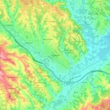
Name: Prnjavor topographic map, elevation, terrain.
Average elevation: 591 ft
Minimum elevation: 417 ft
Maximum elevation: 915 ft
Make a donation
Gear up for your next adventure:
As an Amazon Associate, this site earns from qualifying purchases at no extra cost to you.
Other topographic maps
Click on a map to view its topography, its elevation and its terrain.