
Make a donation
Gear up for your next adventure:
As an Amazon Associate, this site earns from qualifying purchases at no extra cost to you.
Bahía Inglesa topographic map
Click on the map to display elevation.
Make a donation
Gear up for your next adventure:
As an Amazon Associate, this site earns from qualifying purchases at no extra cost to you.
Bahía Inglesa
Bahia Inglesa ("English Bay") is a locality located near the port of Caldera in Atacama Region, Chile. It is situated at an average elevation of 10 meters above the sea level. As of 2017, it had a population of 535.
Make a donation
Gear up for your next adventure:
As an Amazon Associate, this site earns from qualifying purchases at no extra cost to you.
About this map
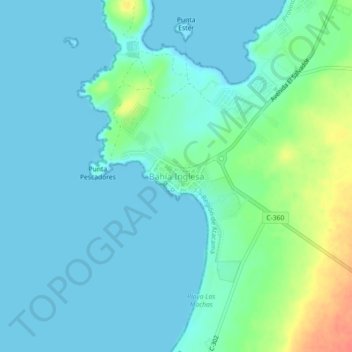
Name: Bahía Inglesa topographic map, elevation, terrain.
Average elevation: 33 ft
Minimum elevation: 0 ft
Maximum elevation: 157 ft
Make a donation
Gear up for your next adventure:
As an Amazon Associate, this site earns from qualifying purchases at no extra cost to you.
Other topographic maps
Click on a map to view its topography, its elevation and its terrain.
Humedal Desembocadura del Río Copiapó
Chile > Atacama Region > Provincia de Copiapó > Caldera
Average elevation: 102 ft
Bien Nacional Protegido Yacimiento Paleontológico Cerro Ballena
Chile > Atacama Region > Provincia de Copiapó > Caldera
Average elevation: 174 ft