Geolocate

Weida topographic map

Click on the map to display elevation.

About this map

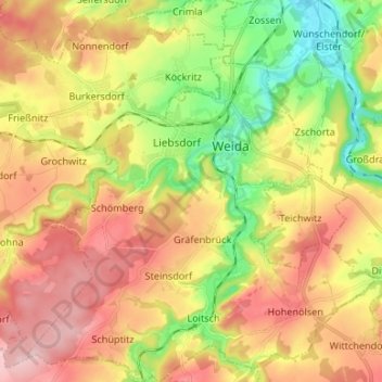
Name: Weida topographic map, elevation, terrain.

Location: Weida, Greiz, Thuringia, 07570, Germany (50.72161 11.98999 50.80583 12.11254)

Average elevation: 1,033 ft

Minimum elevation: 676 ft

Maximum elevation: 1,388 ft

Other topographic maps

Click on a map to view its topography, its elevation and its terrain.

Pansdorf

Germany > Thuringia > Greiz

Average elevation: 1,319 ft

Bernsgrün

Germany > Thuringia > Greiz

Average elevation: 1,585 ft

Zadelsdorf

Germany > Thuringia > Greiz

Average elevation: 1,270 ft

Frießnitz

Germany > Thuringia > Greiz

Average elevation: 1,076 ft

Zeulenroda

Germany > Thuringia > Greiz

Average elevation: 1,332 ft

Gear up for your next adventure:

🧼Biodegradable Camping Soap - Eco‑friendly soap for outdoor hygiene
💧Water Purification System - Clean water on the trail with reliable purifiers
👟Men's Trail Runners - Lightweight footwear for fast-paced exploration and light hiking
😴Insulated Sleeping Pads - Compact and warm pads for high-elevation camping
📱Heavy-Duty Phone Cases - Drop-proof and waterproof protection for outdoor navigation

As an Amazon Associate, this site earns from qualifying purchases at no extra cost to you.