
Hannacha topographic map
Interactive map
Click on the map to display elevation.
About this map
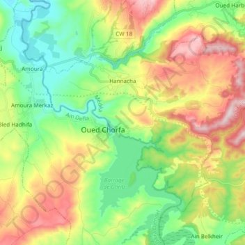
Name: Hannacha topographic map, elevation, terrain.
Location: Hannacha, Daïra Ouamri, Médéa, Algérie (36.12525 2.51780 36.21255 2.66714)
Average elevation: 1,729 ft
Minimum elevation: 1,099 ft
Maximum elevation: 2,746 ft
Other topographic maps
Click on a map to view its topography, its elevation and its terrain.
Oued Harbil
Algérie > Médéa > Daïra Ouamri
Oued Harbil, Daïra Ouamri, Médéa, Algérie
Average elevation: 2,041 ft