
Oued Harbil topographic map
Interactive map
Click on the map to display elevation.
About this map
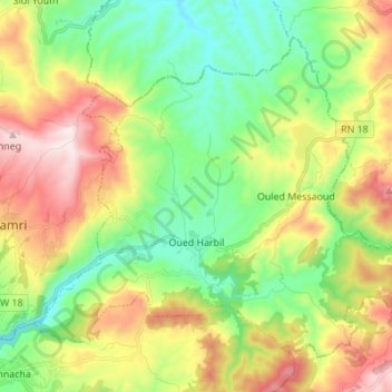
Name: Oued Harbil topographic map, elevation, terrain.
Location: Oued Harbil, Daïra Ouamri, Médéa, Algérie (36.19434 2.57549 36.28493 2.71277)
Average elevation: 2,041 ft
Minimum elevation: 1,270 ft
Maximum elevation: 3,281 ft
Other topographic maps
Click on a map to view its topography, its elevation and its terrain.
Hannacha
Algérie > Médéa > Daïra Ouamri
Hannacha, Daïra Ouamri, Médéa, Algérie
Average elevation: 1,729 ft