
Make a donation
Gear up for your next adventure:
As an Amazon Associate, this site earns from qualifying purchases at no extra cost to you.
Hildfeld topographic map
Click on the map to display elevation.
Make a donation
Gear up for your next adventure:
As an Amazon Associate, this site earns from qualifying purchases at no extra cost to you.
About this map
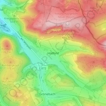
Name: Hildfeld topographic map, elevation, terrain.
Average elevation: 2,234 ft
Minimum elevation: 1,749 ft
Maximum elevation: 2,743 ft
Make a donation
Gear up for your next adventure:
As an Amazon Associate, this site earns from qualifying purchases at no extra cost to you.
Other topographic maps
Click on a map to view its topography, its elevation and its terrain.
Neger
Deutschland > Nordrhein-Westfalen > Hochsauerlandkreis > Winterberg
Die Neger entspringt im Rothaargebirge an der Nordwestflanke des Klappersbergs (729,9 m) auf einer Höhe von 722 m ü. NHN im Naturschutzgebiet Hömberg / Brusenbecke / Eberg / Kalte Spring. Ihre Quelle liegt etwa 1,5 km (Luftlinie) nordöstlich von Rehsiepen, einem Ortsteil von Schmallenberg. Sie fließt…
Average elevation: 1,929 ft