Geolocate

Bulika topographic map

Click on the map to display elevation.

About this map

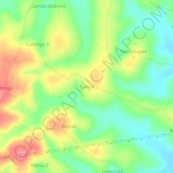
Name: Bulika topographic map, elevation, terrain.

Location: Bulika, Mukono, Central Region, Uganda (0.39955 32.79072 0.43955 32.83072)

Average elevation: 3,720 ft

Minimum elevation: 3,599 ft

Maximum elevation: 3,871 ft

Gear up for your next adventure:

🧤Hiking Gloves - Protective gloves for rugged trails
🪶Camp Gear Gift Set - Perfect gift bundle for outdoor fans
🛌Ultralight Sleeping Bags - Compact down bags for cold nights in the wilderness
🗃️Trail First Aid Kit - Essential kit for outdoor injuries and emergencies
🛰️Handheld GPS Units - Professional satellite navigators for precise backcountry mapping

As an Amazon Associate, this site earns from qualifying purchases at no extra cost to you.