
Thank you for supporting this site ❤️
Make a donation
Make a donation
Gear up for your next adventure:
As an Amazon Associate, this site earns from qualifying purchases at no extra cost to you.
Bhalil topographic map
Click on the map to display elevation.
Thank you for supporting this site ❤️
Make a donation
Make a donation
Gear up for your next adventure:
As an Amazon Associate, this site earns from qualifying purchases at no extra cost to you.
About this map
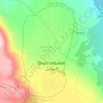
Name: Bhalil topographic map, elevation, terrain.
Location: Bhalil, pachalik Bhalil, Sefrou Province, Fez-Meknes, Morocco (33.84397 -4.87948 33.86792 -4.86274)
Average elevation: 3,041 ft
Minimum elevation: 2,556 ft
Maximum elevation: 3,658 ft
Thank you for supporting this site ❤️
Make a donation
Make a donation
Gear up for your next adventure:
As an Amazon Associate, this site earns from qualifying purchases at no extra cost to you.