Geolocate

Enfield topographic map

Click on the map to display elevation.

About this map

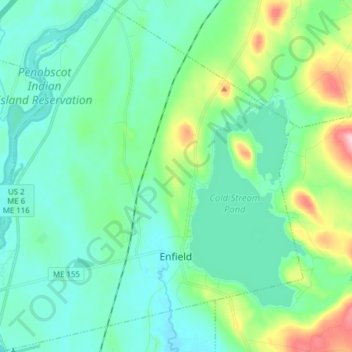
Name: Enfield topographic map, elevation, terrain.

Location: Enfield, Penobscot County, Maine, 04493, United States (45.21941 -68.65317 45.32818 -68.51230)

Average elevation: 249 ft

Minimum elevation: 121 ft

Maximum elevation: 728 ft

Penobscot County trails, hiking, mountain biking, running and outdoor activities

Other topographic maps

Click on a map to view its topography, its elevation and its terrain.

Lincoln

United States > Maine > Penobscot County > Lincoln

Average elevation: 272 ft

Houston Island

United States > Maine > Penobscot County > Winn

Average elevation: 243 ft

Carroll

United States > Maine > Penobscot County

Average elevation: 778 ft

Fairmont Park

United States > Maine > Penobscot County > Bangor

Average elevation: 148 ft

Meadow Brook

United States > Maine > Penobscot County

Average elevation: 325 ft

Gear up for your next adventure:

📷Action Camera - Capture your outdoor adventures in HD
💧Water Purification System - Clean water on the trail with reliable purifiers
🦟Ultrasonic Repellers - Create a bug-free zone at your camp or rest stop
🔭Compact Binoculars - HD vision for scouting terrain and identifying distant landmarks
📱Heavy-Duty Phone Cases - Drop-proof and waterproof protection for outdoor navigation

As an Amazon Associate, this site earns from qualifying purchases at no extra cost to you.