
Make a donation
Gear up for your next adventure:
As an Amazon Associate, this site earns from qualifying purchases at no extra cost to you.
Filan Banco topographic map
Click on the map to display elevation.
Make a donation
Gear up for your next adventure:
As an Amazon Associate, this site earns from qualifying purchases at no extra cost to you.
About this map
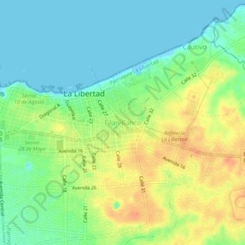
Name: Filan Banco topographic map, elevation, terrain.
Location: Filan Banco, La Libertad, Santa Elena, 240202, Ecuador (-2.24562 -80.92142 -2.20562 -80.88142)
Average elevation: 59 ft
Minimum elevation: -7 ft
Maximum elevation: 144 ft
Make a donation
Gear up for your next adventure:
As an Amazon Associate, this site earns from qualifying purchases at no extra cost to you.
Other topographic maps
Click on a map to view its topography, its elevation and its terrain.
Parroquia La Libertad
Ecuador > Santa Elena > La Libertad
La Libertad es una ciudad ecuatoriana; cabecera cantonal del Cantón La Libertad, así como la urbe más poblada de la Provincia de Santa Elena. Se localiza al centro-sur de la región litoral del Ecuador, en la puntilla de Santa Elena, que es el extremo occidental del Ecuador continental, a una altitud de 10…
Average elevation: 59 ft