Geolocate

Gilwern topographic map

Click on the map to display elevation.

About this map

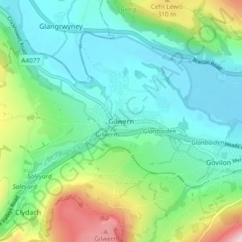
Name: Gilwern topographic map, elevation, terrain.

Location: Gilwern, Monmouthshire, Wales, NP7 0AP, United Kingdom (51.80558 -3.11275 51.84558 -3.07275)

Average elevation: 541 ft

Minimum elevation: 157 ft

Maximum elevation: 1,627 ft

Other topographic maps

Click on a map to view its topography, its elevation and its terrain.

Wye Valley

United Kingdom > Wales > Monmouthshire

Average elevation: 548 ft

Chepstow Castle

United Kingdom > Wales > Monmouthshire > Chepstow

Average elevation: 174 ft

Penallt

United Kingdom > Wales > Monmouthshire

Average elevation: 571 ft

Crucorney

United Kingdom > Wales > Monmouthshire

Average elevation: 974 ft

Blorenge

United Kingdom > Wales > Monmouthshire > Govilon

Average elevation: 1,293 ft

River Monnow

United Kingdom > Wales > Monmouthshire

Average elevation: 564 ft

Llanbadoc

United Kingdom > Wales > Monmouthshire

Average elevation: 256 ft

River Monnow

United Kingdom > Wales > Monmouthshire

Average elevation: 564 ft

Raglan Castle

United Kingdom > Wales > Monmouthshire > Raglan

Average elevation: 194 ft

Gear up for your next adventure:

Backpacking Tent - Lightweight and durable tent for multi‑day hikes
💧Water Filtration Bottles - Safely drink from streams and lakes while exploring
📡GPS Antenna Upgrade - Enhance GPS reception in remote terrain
🎒Outdoor Daypacks - Lightweight backpacks designed for carrying maps and essential gear
🎒Trekking Poles - Sturdy poles for balance and stability on rough terrain

As an Amazon Associate, this site earns from qualifying purchases at no extra cost to you.