
Make a donation
Gear up for your next adventure:
As an Amazon Associate, this site earns from qualifying purchases at no extra cost to you.
Mountain Lake topographic map
Click on the map to display elevation.
Make a donation
Gear up for your next adventure:
As an Amazon Associate, this site earns from qualifying purchases at no extra cost to you.
About this map
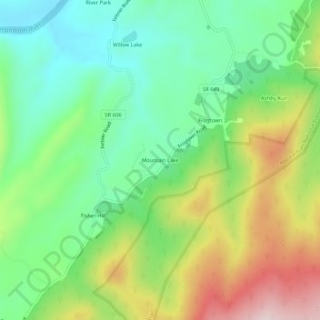
Name: Mountain Lake topographic map, elevation, terrain.
Location: Mountain Lake, Clarke County, Virginia, United States (39.04122 -77.96166 39.08122 -77.92166)
Average elevation: 856 ft
Minimum elevation: 371 ft
Maximum elevation: 1,683 ft
Clarke County trails, hiking, mountain biking, running and outdoor activities
Make a donation
Gear up for your next adventure:
As an Amazon Associate, this site earns from qualifying purchases at no extra cost to you.
Other topographic maps
Click on a map to view its topography, its elevation and its terrain.
University of Virginia Blandy Experimental Farm and Virginia State Arboretum
United States > Virginia > Clarke County > Boyce > Greenway Estates
Average elevation: 594 ft