
Make a donation
Gear up for your next adventure:
As an Amazon Associate, this site earns from qualifying purchases at no extra cost to you.
Veldensteiner Forst topographic map
Click on the map to display elevation.
Make a donation
Gear up for your next adventure:
As an Amazon Associate, this site earns from qualifying purchases at no extra cost to you.
Veldensteiner Forst
Das unbewohnte Gebiet liegt in Oberfranken im Osten des Naturparks Fränkische Schweiz-Veldensteiner Forst zwischen den Ortschaften Pegnitz im Norden, Neuhaus an der Pegnitz und Plech im Süden sowie Betzenstein im Westen auf einer Höhe von 440 bis 512 m ü. NHN. Im Osten wird es von dem Tal der oberen Pegnitz begrenzt, im Westen verläuft die Trasse der Bundesautobahn 9.
Make a donation
Gear up for your next adventure:
As an Amazon Associate, this site earns from qualifying purchases at no extra cost to you.
About this map
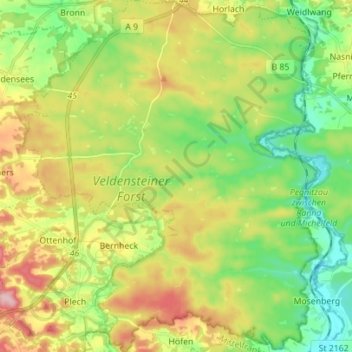
Name: Veldensteiner Forst topographic map, elevation, terrain.
Location: Veldensteiner Forst, Landkreis Bayreuth, Bayern, Deutschland (49.63961 11.44765 49.72975 11.56473)
Average elevation: 1,476 ft
Minimum elevation: 1,247 ft
Maximum elevation: 1,814 ft
Make a donation
Gear up for your next adventure:
As an Amazon Associate, this site earns from qualifying purchases at no extra cost to you.
Other topographic maps
Click on a map to view its topography, its elevation and its terrain.
Waiganz
Deutschland > Bayern > Landkreis Bayreuth > Betzenstein > Hetzendorf
Der im Norden der Pegnitz-Kuppenalb gelegene Weiler befindet sich etwa eineinhalb Kilometer südwestlich des Ortszentrums von Betzenstein und liegt auf einer Höhe von 503 m ü. NHN.
Average elevation: 1,742 ft