
Thank you for supporting this site ❤️
Make a donation
Make a donation
Gear up for your next adventure:
As an Amazon Associate, this site earns from qualifying purchases at no extra cost to you.
Chikhli topographic map
Click on the map to display elevation.
Thank you for supporting this site ❤️
Make a donation
Make a donation
Gear up for your next adventure:
As an Amazon Associate, this site earns from qualifying purchases at no extra cost to you.
Chikhli
Chikhli is located at 20°45′N 73°04′E / 20.75°N 73.07°E / 20.75; 73.07. It has an average elevation of 19 metres (62 ft).
Thank you for supporting this site ❤️
Make a donation
Make a donation
Gear up for your next adventure:
As an Amazon Associate, this site earns from qualifying purchases at no extra cost to you.
About this map
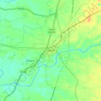
Name: Chikhli topographic map, elevation, terrain.
Location: Chikhli, Chikhli Taluka, Navsari, Gujarat, 396521, India (20.71814 73.01990 20.79814 73.09990)
Average elevation: 75 ft
Minimum elevation: 26 ft
Maximum elevation: 154 ft
Thank you for supporting this site ❤️
Make a donation
Make a donation
Gear up for your next adventure:
As an Amazon Associate, this site earns from qualifying purchases at no extra cost to you.